Today is day 3 and yesterday we traveled a little over 450 miles, including side trips, from Sioux City, Iowa to Rapid City, South Dakota. This took about seven hours, again including side rips and meals. As described in Part 2 of this blog series we were able to accomplish one of our goals of the trip which was to visit the Badlands.
One reader of Part 2 had what I thought was a good question. He asked how could an area of land that looked so beautiful be called The Bad Lands. I really should have addressed that in the post. Fur traders who frequented the area and the Lakota Indians who lived in the area both had names for this landscape that included the words “bad” and “land”. The area is extremely dry, rugged, and subject to weather extremes. When driving and walking through I did not see a single thing growing or animal in The Band Lands proper. For the Indians and trappers who lived off the land this certainly was a bad land. For those of us who can drive through in our air conditioned cars sipping Big Gulps, or walk around with our bottled water, well we have a very different perspective.
Just to the west of The Band Lands are The Black Hills. The area is hilly and dark with thickly populated ponderosa pines. Diving thought the hills and viewing them from a distance they truly did have a very dark almost black look to them. In our driving around we saw several sites where the forest was reduced to stumps and ghostly upright bare trees due to forest fires. Unlike the rugged outcrops and painted layers of The bad Lands, the beauty of The Black Hills was in vastness, serenity, and the collective beauty of the pines.
Back to today’s activity around our base location of Rapid City, South Dakota. The night before we planned to spend day 3 as follows: Mount Rushmore, Crazy Horse, and maybe one or two of the three towns on our list. That was last night’s plan.
We woke to rain. After a breakfast where I ate too many scrambled eggs, too much bacon, and too many Belgian waffles (hey, they were small) we got in the car and headed to Mount Rushmore. Mount Rushmore is twenty-three miles from Rapid City and it is a mountain of some sort so maybe it wouldn’t be raining there. It was. Could not even see the faces of the presidents. Time for plan B.
We decide this would be a good time to visit the three towns on our list since rain was not that much of an issue. In the car again and we headed to Sturgis, about an hour’s drive away to the northwest. If you have any interest in motorcycles (as in Harleys and choppers, and for you old school types Indians ) then you know Sturgis has a huge motorcycle rally for ten days each August. The population of Sturgis is 6,908 and, on average, about 500,000 people show up to have fun. They had a record crowd of 739,000 in 20115. The motorcycle activity consists of racing, stunts, hill climb, and motocross races.
When we got there it was pouring down rain. We happened to see the Sturgis Harley-Davidson dealership and I suggest we go in a look for souvenirs. Like many auto dealerships in the past ten years. Harley-Davidson dealerships had been completely updated to make for clean, inviting, high-tech experience. This store was very nice. I had hoped to get a t-shirt or sweatshirt with Sturgis Harley-Davidson on it. The problem was I am not really into graphic t-shirts and sweatshirts unless the graphic is subdued, preferably just a small logo and maybe a couple of words all printed on the area where a breast pocket would be.
The people at the Sturgis Harley-Davidson dealership have no concept of subdued when it came to their shirts. They were almost all black in color (no problem for me) with graphics either white, yellow, or red, or any combination of three colors. The graphics were huge and covered back, front, and sleeves with skeletons, skulls, skull and crossbones, devils, flames, lightening bolts, American bald eagles, pistols, assault rifles, American flags, Confederate flags, and anything else you can think of that someone would want to wear to try to look like a bad ass o a person who love his country, flag, and guns. I spent a lot of time looking but couldn’t find a shirt that suited me. Neither could any of the other old fogies with me.
We got back in the car drove a block down and turned left to get back on the road to our next town, Deadwood. As we were making the turn we were puzzled by a number of bales of hay and muddy dirt piles up and down the rainy street. At the end of this block we saw a huge bar/t-shirt shop and decided to stop and visit. We parked in a lot across the street and though the rain had let up there was quite a bit of water and mud we had to avoid when crossing the street. I was happy that I was able to get a long sleeve Sturgis t-shirt at the shop that didn’t make me look like a wanna be biker or old hippie. The graphic was about the size of small bumper stick that went across the chest and said Sturgis with some fancy swirling around it. While there I asked the lady at the cash register why all the hay and mud. She said that a motocross race had been scheduled for noon but obviously had been rained out. Bales of hay and dirt mounds had been strategically placed at corners and other spots for the race. End of mystery.
Our next town, Deadwood, turned out, at least for me, to be the best stop of the day. There was still some on and off rain but it wasn’t terrible. Deadwood was a gold rush town in the 1870s after General Custer, who had led an expedition to the Black Hills, announced there was gold in the Black Hills. The town was founded illegally on land “given” to the Lakota people in an 1868 treaty. The town came to be noted for it lawlessness with gambling and prostitution be profitable businesses in the town. Murders were not uncommon with the most notable being the killing of Wild Bill Hickock in 1876. A couple of other old West notables attracted to dead wood were Calamity Jane and Wyatt Earp.
The main tourist area of the town consists of a street with refurbished and replica buildings of its gold rush days. There are saloons gambling places in the saloons and lots of shops. A friend of ours had told us it was a cheap tacky tourist trap but none of us thought so. Yes, it was a place for tourist, but that’s what we were. It was done well, there were lots of interesting shops, and the prices for merchandise and food were not outlandish. We ended up spending about three hours there visiting all the interesting shops, eating lunch at one of the saloons, and playing a little bit of video poker. You sat at a table and dealer on a big wide screen TV dealt your hands. It was fun.
Our next stop was the town of Spearfish. It was supposed to be a good place for boutique shopping. Quite honestly I remember very little about it except that I didn’t think the shopping was that great. The girls loved it so maybe that tells you what kind of shopping the area had, i.e., very little of interest to men.
The visits to these town pretty much covered our day. It was getting late and still raining off and on, mostly on, so we decided to call it a day and go back to the hotel. We would figure out were to eat that night and map out our strategy for the next day, Day 4, which would be our last day in South Dakota. Because of all the rain I didn’t take any pictures, not even with my phone.


Today is Day 4 in the timeline of this blog and its our last day for this area. Yesterday we visited the town of Sturgis, Deadwood, and Spearfish. Tomorrow we start driving to Colorado right after breakfast. Today our goal is to visit Mount Rushmore and Crazy Horse. It’s not raining right now but it is very overcast with off on on drizzling. Since this is our last day we are going to drive to Mount Rushmore to try and get a glimpse of it. Hopefully things will be clearer there. It’s a little over twenty miles away and at a higher elevation so we might get lucky.
Turns out we didn’t get lucky, it was drizzling and overcast there too. We parked and walked up to the monument anyway, just to be sure. The walk from the car to the monument was a bit of a distance with the on and off drizzle. When got all the way up to the guard rail in front of the monument we could not see a single thing; just a complete wall of gray cloud. Wow, we put just over 1,000 miles on the car for this? Trying to make lemonade our of a lemon we took a selfie of us in front of the invisible Mount Rushmore to add another road trip update for our Facebook friends. We spent some time in the large gift shop and in a tourist info office and history museum. A lady there said she couldn’t remember the last time they had September weather like this so that people couldn’t see the monument two days in a row.
We headed back to the car to come up with a plan B. We decided we would drive through Custer State Park and then go to the Crazy Horse Memorial hoping the weather would be better at that time. We had all day so we thought we’d take Iron Mountain Road to the state park. The info we got online was that it was 17 miles long and took one hour to drive. They were right. Lots of turns and twists and switchbacks through a very mountainous, dense forest. The coolest thing though was a unique circular, spiral bridge in one spot that took you up or down in elevation without having to travel the distance that would be required by switchbacks.
After that section of road we decided we’d take the Wild Life Loop Road through the park. Our phone GPS said it was 18 miles and took 1 hour and 30 minutes. (One does not go anywhere fast the the southwest corner of South Dakota.) It was a steady light rain though the park and we didn’t see much wild life, just some elk one time and some bison another but the animals were quite a distance from the road. Toward the end we came to the park’s lodge. A very large, beautiful, and lodge-like building . You know, lots of stone and logs on the outside and dressed stone and lacquered cedar on the inside with large rooms with big fire places. It was near lunch time so we decide we’d eat there. Being out in the middle of nowhere we weren’t sure where the next food stop might be and we we not the types who like to miss a meal. The food was very good. I had a cheeseburger, my friend B had a bison burger, and I don’t remember what the girls had, probably something that had grilled chicken.
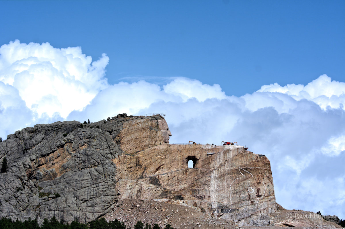
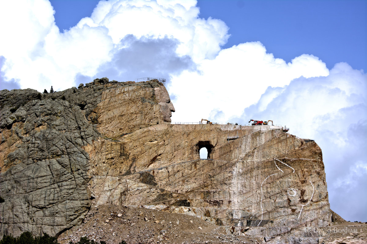
After lunch we headed toward Crazy Horse. The park had been at a much lower elevation than Mount Rushmore and it felt like we were driving through a deep valley most of the time. As we started to come out of the park and gain elevation the rain stopped and the sky began to clear. By the time we got to Crazy Horse there was not rain, but lots of clouds and blue skies. Things were looking good for our Crazy Horse visit.
The Crazy Horse Memorial is under construction and has been since 1948. It receives no state of federal funding and funding from the federal government has been turned down twice. Funding for the non-profit organization responsible for the monument comes form admission fees, gift shop sales and donations. Crazy Horse is probably best know as the Indian chief who defeated Custer at the Battle of the Little Bighorn. Despite this being a memorial to the spirit of Crazy Horse and Native Americans there is controversy concerning the monument among some Native Americans. That controversy is describe at the bottom of this Wikipedia article.
With plenty of sunshine for a change I was able to take pictures at the Crazy Horse Memorial.
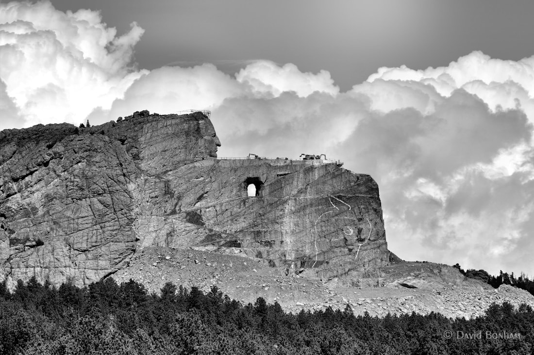
Different shot, same view, black & white.
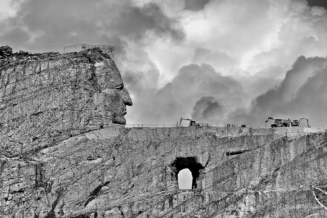
The long reach of an 80-400mm lens on a crop sensor camera
The white drawing at the bottom front of the monument is an outline of what the horses head will look like. Sometimes I see it and sometimes I don’t. Basically the horse’s head is pointed nose down.

If you would like to see what the finished monument will look like compared to its present day status click on this link: Crazy Horse.
As we were driving back to our hotel from Crazy Horse we commented on the fact that the Iron Mountain Road and the Wild Life Loop Road drives were very nice, unplanned surprises. We also noted that at least we were lucky enough so that on our last day, and during the last few hours of the day, we did get to visit another of our planned objectives for the trip. In fact, despite all the rain of the past two days we had seen every thing we had come to see … except for Mount Rushmore, our primary objective. One item that wasn’t a definite plan (more of it would be nice if we could) was visiting Devil’s Tower in Wyoming. We’d think about that in the morning.
Tomorrow we wake up and head for Colorado Springs, Colorado.
Thank you for stopping by.
David

Liking this road trip revue, shame about the weather but as they say sh*t happens. I used to own a Harley and I know exactly what you mean about the dealerships and merch, complete rip-off!
LikeLiked by 1 person
Thank you. In 1970 when stationed at Ft. Ord in Monterey, California I bought (for $300 that a friend lent to me) a used Yamaha 100 cc twin cylinder motorcycle. When revved it literally sounded like a sewing machine … riiiinnnngggg ding ding ding. But it got me off base and all around the Monterey Peninsula and Salinas Valley.
LikeLiked by 2 people
That was a lot of money back then! My first bike an old Honda 125cc twin in 1974 cost £60 ($40?)
LikeLiked by 2 people
Yes it was a lot. I wanted to pay back my friend right away so he and I had agreed to $100 per month. At the time I was getting about $230 a month so I had to start eating in the mess hall again and curb my week end nights out at the local country western bar. 🙂
LikeLiked by 1 person
Wonderful history. For me, the second one is the best.
LikeLiked by 1 person
Thank you CarMac. I have two more parts planned in my mind that I’m trying to condense into just one more part to the series. Hopefully it will rival Part 2. 🙂
LikeLiked by 1 person
I just recently took a trip out west to Yellowstone, the Badlands, and the Black Hills. It’s a truly amazing part of the country! Our family had the same question about the Badlands until we looked at them from a pioneer’s point of view — the Badlands must have been a terrifying obstacle.
LikeLiked by 2 people
Good point. I hadn’t thought about the Badlands in terms of an obstacle but than would have been exactly what they were when the only transportation was foot or horse and you couldn’t just zoom through them on a paved road in an hour or so.
I’m curious, have you given up on your blog site?
LikeLike
Sorry to hear your missing Mt. Rushmore with all rain. We stayed at a campground in Spearfish back in August 2016 for eight days and visited the same places you did in this post, enjoyed them all. Sturgis week had just ended a few days prior, when we were there the bars still lacked booze and food, lol. If we ever get back to camping, we would like to stay & revisit this whole area again for a couple more weeks. So much beauty, and we totally loved the wildlife loops and switchbacks. I blogged back then on some of our adventures, I really had fun photographing the mountain goats walking up the side of rock.
LikeLiked by 1 person
Sounds like good times. There are a few places I’ve been with friends that I’d like to revisit. My friends are very understanding (they’ve been watching me photograph things and them for 50+ years) but I’ still conscious of the fact that I can’t just take 15 minutes for one subject when ever I want to.
LikeLiked by 2 people
I am ‘pulled’ along by any one and everyone who is out with me and my camera, including my husband. When the groans start, I know it’s time to go. 😉 I’d really rather go alone on my photographing adventures, but then I won’t come home til the cows do….
LikeLiked by 2 people